Utah
November 5, 2017 through November 8, 2017

We crossed into Utah and immediately the roads were better and we felt free of a weight. There was no past to uncover or people to visit in Utah. Natural beauty and places we might want live were ahead of us.
We followed the Colorado River into Moab. Stunning. We stopped frequently.


After setting up a place to stay, the very place Dan stayed with his cycling buddies twelve or so years ago, we went straight to Arches National Park for the winding drive among towering rocks.
We passed through the rock formations known as the Three Gossips, the Organ, the Tower of Babel, and Sheep Rock.


On our way out of the park, we stopped there again and I stepped down into the canyon and onto the Park Avenue Trail. The rock is so massive that stepping to a lower elevation enabled me to see parts that I couldn’t from so high up. There was something comforting about walking in the canyon, stepping in sand, shaded, watching sun shadows play high above. I didn’t want to leave.


We followed nature’s Great Wall to the Windows area to see the Balanced Rock, the Double Arch, and the North and South Windows. From the right angle, the South Window looked like Africa.


We chose not to walk to Delicate Arch. It’s a bit of a hike that you’ve got to be prepared to make (water, time). Instead, we stopped at two different viewpoints. The Upper Delicate Arch Viewpoint provides a closer distance after a short, steep walk.


The Arches National Park Road doesn’t make a loop, so you decide when you’d like to head back the way you came. We decided to drive to the Fiery Furnace Viewpoint, which also provided panoramic views of the area.


Moab is a small, outdoor adventure enthusiast, artistic community that I liked. It looked like there was always something going on. That weekend, there was a Celtic Festival, a Folk Music Festival, and a running marathon, yet we didn’t feel surrounded by people. There was space to breathe and enjoy. We walked Moab’s streets, stopped in a trendy bakery and coffee shop for breakfast, sampled beer from the Moab Brewery, and even went to a movie in the small, hometown, barely-ever-cleaned movie theater just behind our motel.
Could I live there? Yes, I could.


The next day, Dan took us along forty-six miles of jaw jarring, hairpin twisting dirt road for a six mile hike down into and back up from an amazing canyon. Kiva is not allowed to get out in the national parks, but this time, we were remote enough that she could come with us.
I could tell you its name and provide a map about how to get there, but I’m not going to and this is why. The people of this age on earth have become tourists of the planet and the beautiful places are becoming congested and commercial. You can hear every language in the world and that’s a great thing, but the trade-offs are crowds, quick views, and difficulty getting the feeling for the place in all the chaos. We did not enjoy our time at the Grand Canyon or in Sedona very much for this reason.
So, there’s this great canyon. Turns out it’s not far from where the guy portrayed in the movie 127 Hours got his arm caught while managing a crevasse. Get in touch with me if you must know where.


The first thing I noticed is that rock is much easier for downhill stepping. I’m used to slidy, loose gravel, like at Angel Rocks outside of Fairbanks, and I found I could move downhill much more quickly than usual when I was confident that my step would hold.

Compare the top and bottom photographs. Same direction. The first one is higher up. I was intrigued by how I saw things differently moving lower into the canyon.

As we moved along the backside of the canyon wall, we met a man in a neck brace. Dan exclaimed, “You’ve really got to want to do this hike if you’re doing it in a neck brace!” He was hiking with his daughter and his brother in the hat, who had stopped to sit further along. They were going to see how far they could get. Their parents got engaged over on the flat rock face opposite; their initials were carved there along with the date 1937. It was a quest much like the one that brought me up into the Rocky Mountain hills of Eldorado Springs. Love has a power for generations, I suppose. Perhaps their long gone spirits dwell where they fell in love. Perhaps they were happiest in those places. What is the pull of our ancestral past? Do we understand anything about what it does to us, what it binds us to?

We spiraled down the canyon wall and trudged through the sand in the cool quiet of the canyon floor. There is something wonderful about walking at the bottom of a canyon. Sheltered. Protected. Peaceful.


There was a beautiful leaping deer, and another, and another, and another! Gracefully, they scampered in the direction we needed to go to see the first pictographs in the canyon wall.
The best that can be determined is that there has been human presence in the canyon since 7,000 to 9,000 BC. The pictographs are dated between 400 AD and 1100 AD.
Pictographs are paintings on stone with natural pigments and dyes. In contrast, petroglyphs are images carved into stone. Pictographs are more vulnerable to wearing, so they tend to be found in protected areas, like canyons and caves.
The first thing of note about the pictographs is that they are big. The second is that there are figures with small heads and vase-like bodies. I’d never seen anything like it before.
We walked to another area of pictographs on the other canyon wall before continuing through the bright yellow cottonwoods and salmon colored sand to the Alcove.


The Alcove set into the wall. Its acoustics were amazing! I could imagine people living there. Lots of people. A bustling community. It was possible to step up onto a rise and get closer to the pictographs on the walls. Animals and strange jar-like beings with small heads and without arms and legs.
We continued on our trek, the canyon winding around, and at last reached the celebrated Great Gallery. Huge figures. As big as a real-life person. So high up it quickly began to hurt my neck. And some tiny figures that looked more like people and animals. That was my first clue that maybe Dan’s idea that that the jar-like beings with small heads represent a visitation by beings from another world was not so far off base. There was a contrast represented between humans and these beings, real or imagined. I thought of the giants of old that run through just about every mythology on earth. In the Bible, they are the Nephilim; they were destroyed at the Flood.


“There it is,” Dan said.
He pointed to what is perhaps the most famous part of the Great Gallery. It’s known as the Holy Ghost Panel. Perhaps you can see why.

What is that ghostly figure?
“I think they were visited by aliens from another planet,” Dan said matter-of-factly.
Whether imagined or real, the figures do appear to be different from humans. Perhaps they are a representation of life after death? And there is certainly nothing that rules out the possibility that beings from other worlds visited our planet.
“We’re losing light,” Dan said as he headed back. I took my time, enjoying the flat red rock that went up forever around me, the thick salmon sand, and the gold leaves.


Kiva kept stopping to rest in the sand. The sky was turning pink and there were shadows across the canyon as we climbed back up.


It was twilight as we got into the truck. We were the only ones on the winding gravel road as the stars came out.
The next day, we lingered along the main street of Moab, not eager to leave. I found myself looking at posted announcements for employment and community activities. Then, we headed west.


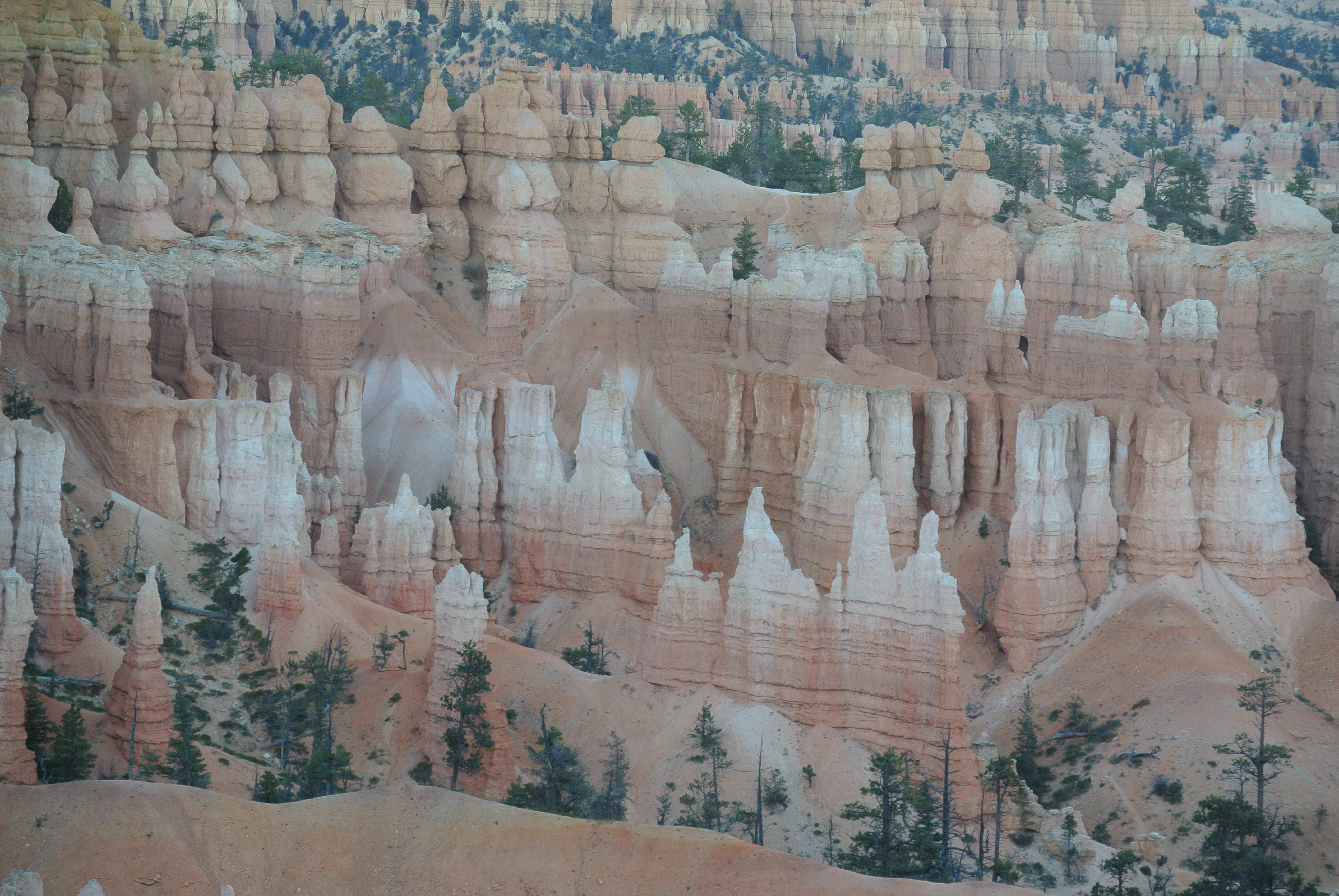
We drove west to Bryce Canyon. We stayed at Ruby’s Inn, which is a historic place first started by a man named Reuben who was an early tourism pioneer for the area back in 1916. Ruby’s Inn is a Best Western, but it’s more like a small international village complete with post office, laundry, general store, large scale buffet restaurant, and an enormous store with all sorts of jewelry, books, rugs, pottery, you name it.
We went to the nearby park entrance and stopped at Sunset Point just before sunset. It’s not important to be at any of the points at any certain time. It seems to be best to view the beautiful hoodoos at various times of the day.
According to legend, the hoodoos are unfortunate souls who were turned to stone by the trickster coyote. They have many colors and change color in different light. The beauty is spectacular.
We drove the twenty or so miles of park road, again not a loop. The highest elevation was at the end at Rainbow Point: 9,115 feet. I could feel that elevation. The thousands year old Bristlecone Pine Trees grow there, so we walked the loop trail and looked for them, touching their needles.
To read one of my old poems about the oldest Bristlecone Pine Tree, go here: A Chat with Methuselah.
We stopped at Sunrise Point, Sunset Point, Inspiration Point, and Bryce Point over the evening and morning of our visit before heading south into Arizona. Many consider the area to be the most beautiful in Utah.
And now…the many shapes and colors of Bryce Canyon…


